
The waterfront property community has always been self-reliant and resilient in the face of adversity. FOCA advocates personal responsibility for every waterfront property owner, as part of good risk management.

Whether flood, drought, or other severe weather events, it falls to each of us to be reasonably prepared for emergencies that can arrive with force and little warning.
NOTE: All flood advisories are not the same. Flood message definitions – watch, warning, etc. – can be found near the bottom of this Ontario webpage
Jump to FOCA’s Low Water/Drought information
Jump to FOCA’s High Water/Flooding information
Jump to FOCA’s Water Management Planning webpage

Is there an emergency in your area?
- consult the map and messages from Ontario’s Flood Forecasting and Warning Program
- visit Environment Canada’s website for current weather information and notices
Have you been flooded?
Be aware that many home systems may be affected; learn more about managing impacts to structural, electrical and other home systems from the Government of Canada Get Prepared webpages.
For information about how to manage their septic systems during high water, and after the water recedes, see this guidance:
- Septic Systems After Flooding (HKPRD Health Unit)
- Flooded Wells and Septic Systems (PDF, 4 pages)
- Septic Systems – what to do after a flood (U.S. Environmental Protection Agency)
Also read this 2019 post to Water Canada’s website, “Bad Weather can lead to Bad Water,” about drinking water quality concerns after high water events.
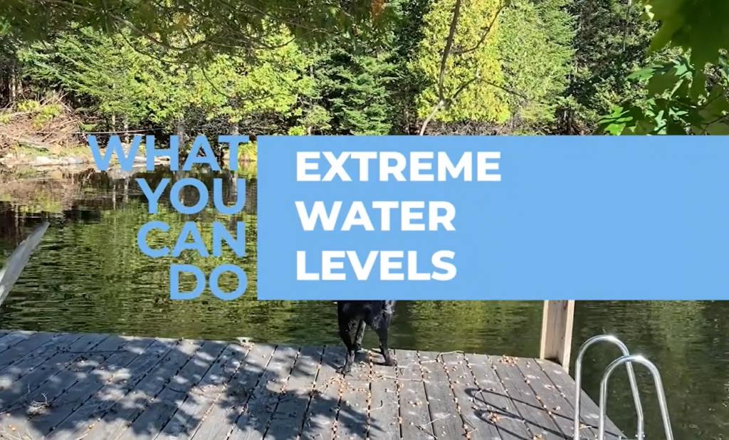
Have you ever wondered about high & low water levels throughout the Trent River Watershed – where the water comes from, where it goes to, and who manages the levels throughout the seasons? The Coalition for Equitable Water Flow (CEWF) has created some great and informative videos on the subject, and how to protect your property from fluctuating water levels:
- Extreme Water Levels – Understanding the TSW and Climate Change (posted to YouTube, June 2023)
- Extreme Water Levels – Protecting Your Waterfront (posted to Vimeo, April 2023)
RECENT NEWS:
April 25, 2026 – Ontario Flooding Update: Gravenhurst Official Warns Not to Launch Boats Yet (Weather Network video)
April 22, 2026 – Timmins Area Flood Warning – Mattagami River Water Levels Continue to Rise (Mattagami Region Conservation Authority)
April 20, 2026 – Here’s how flooding is impacting travel in northeastern Ontario: Several local roads, secondary highways shut down due to high water levels (CBC News) – Sudbury, Elliot Lake, and other locations
April 19, 2026 – Quebec, Ontario communities grappling with spring flood conditions (CBC News Video)
April 19, 2026 – Bracebridge under flood warning as rain, melting snow swamps Ontario cottage country (MSN.com)
April 18, 2026 – French River, Ont., mayor says community bracing for more flooding, province sends volunteers to help sandbag: States of emergency still in place on Manitoulin Island, French River, Chisholm Township (CBC News)
April 18, 2026 – Why Ontario’s Cottage Country Is Flooding So Badly This Year (video – The Weather Network)
April 18, 2026 – Parts of Ontario are approaching wettest-ever start to spring (The Weather Network) – Ottawa River system, Muskoka-Trent-Severn and Algonquin corridors, Northeastern Ontario
April 17, 2026 – Flood warnings in place for Ontario’s cottage country as warm temps, rainfall swamp communities: Bracebridge-Minden-Parry Sound district under flood warning, some parts of Ont., declaring states of emergency (CBC News)
April 17, 2026 – Flooded driveways and washed out streets impacting residents north of Sault Ste. Marie, Ont.: Evacuations are underway in Goulais as warm temperatures and melting snow have caused significant flooding in the area (CBC News)
April 16, 2026 – Flooding worsens in cottage country (City News – YouTube video)
April 16, 2026 – Spring flooding swamps parts of Ontario, threatens parts of Quebec (CBC News – YouTube video)
April 16, 2026 – Massive sinkhole opens as flooding hits Minden, Ontario (The Weather Network)
April 15, 2026 – Spring flooding prompts Minden Hills, Ont. to declare state of emergency (Global News)
March 28, 2026 – Nurturing forest health may ameliorate spring flooding: Muskoka Watershed Council (MuskokaRegion.com)
July 2025 – NEW! Read the full Case Study from a fellow FOCA member group, about local water management planning:
You're missing members-only content!
The offer access codes are only available to members of our Member Associations.
If you are already registered on the FOCA website, please login below with your Username and Password.
Need help with your login? Contact us for assistance during business hours. Not yet a Member Association? Find out why you should be!

Learn about personal Emergency Preparedness in remote areas. Take steps to prepare your property for weather and water extremes. Review your insurance coverage and understand what is covered, and what is not.
FOCA reminds everyone that any waterway has the potential to be dangerous during extensive rain or strong wind events, as riverbanks become saturated and slippery. If you are out boating, be #WakeAware as high water conditions mean more threat to docks, shorelines, and loons nesting along our waterways.
More High Water / Flooding information:
Links to water level resources & flood tips:
- Ontario Flood info: before, during and after
- Insurance Bureau of Canada – 4 ways to prepare for water-related damage; and related resources
- Ontario’s Surface Water Monitoring Center website
- Trent Severn Waterway Water Level Graphs
- Rideau Canal Water Level Graphs
For more information regarding watershed status, please visit the website of your local Conservation Authority: Kawartha Conservation, Otonabee Region Conservation Authority, Ganaraska Conservation Authority, Lower Trent Conservation Authority, Lake Simcoe Region Conservation Authority, Cataraqui Region Conservation Authority.
In all other areas of the Trent, Severn and Rideau Watersheds, see the Ontario Ministry of Natural Resources and Forestry for notices.
Are you Prepared for Flooding?
Ontario cottage-country communities should be vigilant especially in the spring, as this is the time of year when we can experience lots of melting snow and ice, heavy rainfalls, and high water flows on lakes and rivers. Conditions can change quickly, so being prepared in advance is the best possible approach.
The “freshet” is the Spring thaw of snow and ice in our watersheds. Quick melts and heavy rain can result in flooding, as ground that is still frozen cannot absorb the moisture.
FOCA and our local associations remind all homeowners to take measures to protect themselves and their belongings. Cottage country buildings, docks, and boathouses located in or near the floodplain are at particular risk. Preventative action can minimize loss, but overland flooding is a real risk for those located in a flood plain or close to rivers or lakes.
Critical risk factors for waterfront homes:
- If you have buildings, docks, boathouses, decks, equipment, boats, stored or located in the floodplain, or near the high water level of your nearby lake or river – you may be at risk.
- If your lot is not graded so that water flows away from your house, overland flows may impact your foundation or basement
- Poorly drained lots (frozen or shallow soils, rock, or clay) can cause poor surface drainage. Runoff from heavy rain or melting snow can result in standing water, flooding, foundation settlement or damage, or basement dampness. A well-planned drainage system will help keep your lot, and your neighbour’s, free of standing water.
What you can do:
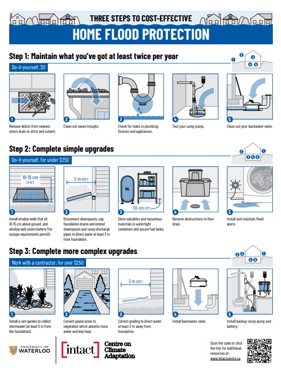
- Read “Three Steps to Cost-Effective Home Flood Protection” (download PDF, 1 page) by our partners at the Intact Centre on Climate Adaptation
- Clear eavestroughs and downspouts – if safe to do so – to direct water away from your home.
- Ask someone to check your property if you are away for extended periods.
- Review your insurance policies – call your insurance professional if you have questions about your coverage, particularly related to overland water.
- Move valuable items from the basement to upper floors.
- Steps to take after a flood (Government of Canada)
- Dry any flooded areas quickly, to prevent mold growth. Industrial-sized air dryers are often used in these instances and are typically available for purchase or rent at one of the major hardware stores. If the water is from a freshwater source, quickly retrieve from the flooded area any valuables. If the flood source originates from the septic system, avoid contact with the water and do not cross-contaminate unaffected areas by walking in and out of the contaminated areas.
- What to Do When Flood Waters Have Affected Your Septic System (Leeds, Grenville & Lanark District Health Unit)
Flooding and Insurance Coverage:
Flood damage caused by overland flooding is not generally covered by home insurance policies in Canada (though a few companies may now have it available), so it is important to protect yourself from the potential damage of floods. Flooding from sewer or septic system backup may be covered, but in any case it is important to understand your home insurance policy to see if these types of coverages are included.
FOCA reminds members:
- Ontario homes are limited in insurance coverage for damage due to overland water
- seasonal properties are NOT covered by the Ontario Disaster Relief Assistance Program, a provincial financial assistance emergency tool.*
* About ODRAP: The Ontario Disaster Relief Assistance Program (ODRAP) is a provincial financial assistance program intended to alleviate the hardship suffered by private homeowners, farmers, and small businesses whose property has been damaged in a natural disaster declared by the Minister of Municipal Affairs and Housing. ODRAP is not an alternative or a substitute for private insurance coverage and risk management. Damage claims should be directed first to insurance companies to determine coverage of individual policies.
About the risk of flood and the role of planning:
October 2025 – Flooding is the most frequent natural disaster in Canada with 2 in 10 Canadian homes at risk. Over the past decade, FOCA has been proud to participate in the Partners For Action (P4A) initiative to empower Canadians to become flood resilient.
As P4A winds down now, the University of Waterloo has written a reflection on P4A’s decade of impact and legacy – including FloodSmart Canada, which for a long time was the only site where the public could access flood maps. Consult earlier P4A resources lower down on this webpage.
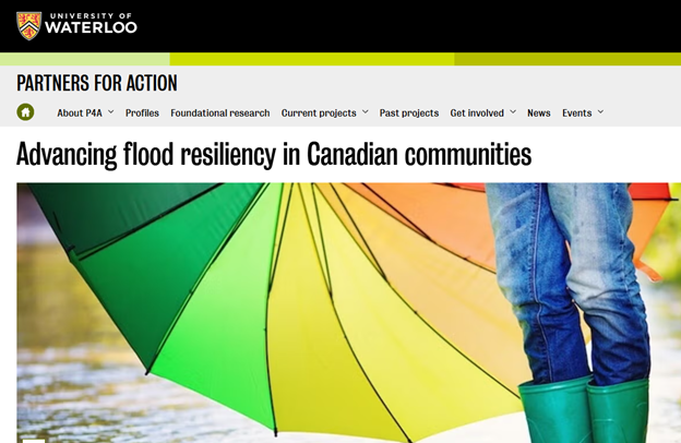
FOCA is in the P4A (Partners For Action) Stakeholder Group, as part of our ongoing interest in making our communities stronger in the face of climate change. In July 2016, P4A released a new report: At the Front Lines of Flood: How Prepared are Ontario Communities? Some highlights:
- Flooding is a major source of socio-economic vulnerability in small and medium-sized Ontario communities, placing unnecessary strain on municipal resources
- Communities are acting to manage vulnerability to flood, but these efforts are fragmented, creating uncertainty about their effectiveness. Communities also lack institutional and financial capacity to enforce, update and further invest in these actions to improve resiliency
- Federal and provincial policy and funding to reduce vulnerability and improve capacity of our communities to prepare and recover from flood are underutilized and underdeveloped
- There is a strong divide in capacity to understand and address flood risk between urban and rural communities
- Municipalities need funding, capacity, technical and scientific support, regulation, and community and political buy-in to address the present and future risk of flood
- Provincial and federal governments should address the current leadership gap and prioritize community resiliency to flood by supporting communities in understanding and communicating risk and opportunities to reduce this risk.
Recent News:
October 10, 2025 – Low Water Notice for the Trent Severn Waterway– FOCA was sent this notice from Parks Canada, and has shared it with our association representatives on the listed lakes.
October 9, 2025 – Several Quebec municipalities have had to import water due to drought (City News – Montreal) – St. Lawrence River freight is impacted, and many boaters are struggling to winterize their boats as the water level is too low to reach the cranes at their marinas
September 4, 2025 – Kingston, Belleville areas the latest to face critically low water levels: 4 of eastern Ontario’s 6 conservation authorities have severe low water alerts (CBC News)
Ontario Low Water Map at September 2025 (see link below)
Low Water / Drought Information:
The summer of 2025 was hot and dry, leading to low water concerns in some parts of southern Ontario in particular.
Important links:
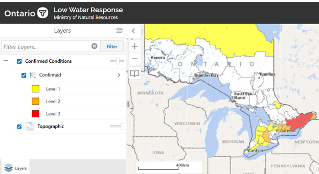
- the Province of Ontario maintains a Low Water Program – consult their webpage for a map of low water conditions and additional information: https://www.lioapplications.lrc.gov.on.ca/webapps/swmc/low-water-response/
- For more about drought, consult the province’s webpage: https://www.ontario.ca/page/drought
- For FOCA members with properties in regions covered by a Conservation Authority (CA), consult your local CA that issues high and low water alerts on an ongoing basis. Most CAs include “red-orange-yellow-green” warnings on their website landing pages, and may also have an e-list you can subscribe to, for regular updates.

Please note: the following is archival material, and some links to third-party resources may no longer be active.
For related topics, visit FOCA’s additional webpages:
Emergency Preparedness in Remote Areas